
My logistics for most of my walks involve driving to the end point, getting public transport to the start, then walking back to the end. That way I don’t have any time constraints, buses or trains to catch, and I can collapse into the car when I’m hot, wet, sweaty and unpleasant to be around. However, today I need to get from Silloth to Maryport, on a Sunday. That involves a bus to Wigton, then a train to Maryport. I realise that if the train doesn’t turn up – and remember this is a Northern Trains service on a Sunday on a rural line, so that’s about a 90% chance – I’ll be stranded in the middle of nowhere (sorry Wigton, but you really are right in the middle there).
So today I’ve decided to use my new toy….

I drive to Silloth and park up just north of the town. I get the bike out of the car, unfold it, power it on, and realise it only has 4 bars out of 5 on its battery indicator. Not a good start, but it should get me to Maryport as long as I help it out a bit by pedalling.
The start of the journey involves riding through Silloth town, over bumpy cobbles, which is really unpleasant (the cobbles, not the town). Half-way to Maryport the heavens open and I get thoroughly soaked. Luckily I’m in shorts today rather than my usual jeans, but my socks and boots get soaked through, and I spend fifteen minutes or so sheltering under a tree to escape the worst of it.
Electric bikes are fab. Most of the journey I can’t be bothered pedalling and just let the motor do the work. 12 mph does seem awfully slow though – I stop and take a look on YouTube for any button press sequences I can do to unlock the speed limit, but can’t find anything that doesn’t involve taking it apart. Oh well.
The battery finally gives up about a hundred yards to my destination, on the promenade at the northern end of Maryport, and I have to pedal the remaining distance. I lock the bike up, and change my socks to a dry spare pair I’ve brought. My boots are still wet but it’s a slight improvement.

A slope takes me down to the beach, at the top of which are pavements of red sandstone, carved into graceful curves by the sea.

I decide the beach is too rocky to traverse easily and retreat back to the promenade, at the end of which there’s a colourful hut and a bench commemorating the 75th anniversary of VE day.


Although it’s stopped raining, it’s still a pretty gloomy day. The hulking giants of the mountains of Dumfries and Galloway over the water look grey and indistinct through the damp air.

I suspect the photographs today won’t be as clear as normal. Knowing it was likely to be a wet day, I’ve brought along my new waterproof camera, a Praktica WP240. It’s only a cheap thing with a 4X zoom whereas my normal camera is 60X, but at least it’ll survive the downpours today promises. I’m still getting used to it, particularly it’s annoying habit of occasionally pausing a couple of seconds before taking the picture…

After a mile or so I drop down onto the beach, now that it has become more sandy and level. It’s a very nice beach, which I have all to myself…

…well, except for some tired seagulls taking a mid-day break.

I wander down towards the sea, where the sand is firmer and easier to walk on. Occasional streams are generally easy to cross without getting my feet any wetter, until at one point I sink down to my ankles into some silty mud. The silt looked almost identical to the sand, but the result is very different – wet and very muddy feet.

I utter a few profanities, and skirt around the silty area, although it’s very difficult to tell what is sand and what is muddy silt. By the end of today’s walk I will have strayed into at least another three mudbaths, as it takes a bit of experience to spot the subtle visual differences in the surface features of firm sand and soggy mud.
I’ve been drying the socks I cycled in by hanging them from a carabina on my rucksack. They’re almost dry, but there’s nowhere to sit down and change them, and my boots are so filthy I don’t want to touch them, so I don’t bother.
I reach the village of Allonby, through which I’d previously cycled. There wasn’t much there so I stay down on the beach, although I really fancy a cup of tea and a cake. I’m not sure any cafe would let me in with the state of my boots anyway, certainly not any that I would like to visit.

At the northern end of the village stands the huge almshouses building. It was built in the early 19th century for a Quaker, Thomas Richardson. According to Parson & White’s, History & Directory of 1829…
“Thomas Richardson, Esq., of Stamford Hill, near London, is a native of this town, where he has lately built a handsome mansion for his occasional residence. The two wings of the building are formed into six cottages, in which Mr Richardson generously allows as many poor families to live rent free.”

Unfortunately times have changed. Most rents these days are extortionate, let alone free! Low-cost affordable housing is now supposedly a requirement of new developments (although most seem to get section 106 exemptions), and this building is now “ten individual homes” which are up for sale. Probably not very affordable.
At Dubmill Scar, a stream poetically called “Black Dub” splashes out of an ugly concrete culvert and onto the beach. Dub is the Celtic word for Black, so this stream is really called “Black Black”. Much like the River Avon, which means “River River”.

Beyond the black black, a series of groynes punctuate the beach, which by now I’m starting to get a little bored of. They add a paltry crumb of interest to what is becoming a bit of a slog.

Six miles of beach so far. I’ve got a bit bored walking along beaches before, notably Formby, and the feeling is rapidly returning. There just isn’t that much to look at…

The view towards the sea is marginally more interesting, as the light reflects off the pools…

I spot a wooden footbridge up at the top of the beach, and hoping for a change of scenery, or even a more solid path to walk along, I head up to it.
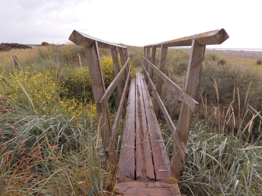
At the other side of the bridge lies a carpet of succulent plants and pretty white flowers, beyond which the path promptly dumps me back onto the beach.

Another three miles of endless beach, then woohoo!.. in the distance there’s something to see!

That’s Silloth, my destination for today. The rightmost tiny upright building is the spire of Christ Church. It’s still several miles away yet though. Meanwhile the beach goes on and on and on and on…. until a path appears leading away from the beach. At the base of the path, as if marking the escape from endless miles of sand, is a little tower of stones. Stone balancing has become quite a thing recently, and there are some spectacular achievements to be seen on the internet, even amazing arches. This is much simpler, but still quite nice.

The sandy path leads up onto a grassy patch and a path then meanders north along the dunes at the top of the beach. This is nice, a different surface, and a different view.

Unfortunately, after no more than a couple of hundred yards, the path narrows into tall vegetation, soaking my boots again that had just got a little drier, and my shorts too. It then promptly dumps me onto the main B5300 road. I backtrack and climb down a pile of coastal protection rocks and back onto the beach. Oh look, more sand…

Although it is now a couple of hours after low tide, the sea is still several hundreds of yards to my left. In fact, a sand bank seems to stretch most of the way over the Solway Firth towards Scotland. On the OS map it’s marked as a sand island called “Middle Bank”, but right now it is still connected to the sand on the English side. It really does look like I could walk to Scotland from here, but I know the Solway Firth is still very deep at this point, up to 14 metres at some points according to nautical charts.
A disruption in the sand catches my eye, and I wander down the beach a little to investigate. Someone has dug an arc channel in the sand. It looks a bit strange for something kids might have done, not in a particularly nice part of the beach, and a long way from any car parks. It must have been made by aliens.

A few minutes back I was peering at a tower a little further down the beach, and wondering whether it was originally a lighthouse structure. As I pass it a few minutes later the water has already risen around it. The tide is coming in very fast, although I’m in no danger where I am. Looking at the OS map it is indeed a light tower, on “Lees Scar”, although it clearly doesn’t have a light anymore.

The Lees Scar Lighthouse has some history. It was built in 1841 on a shallow outcrop of hard clay, and equipped with a fog bell, and a light. For a while it was manned by a keeper called Tommy Geddes, from whence it acquired its local name ‘Tommy Legs’. The 7th September 1906 edition of the Carlisle Journal apparently reported the drowning of the Silloth lighthouse-keeper Samuel Jardine on the previous Saturday…
He had been in the job for some time and usually walked out to the Lees Scaur lighthouse at Low Water, when it was safe to negotiate a number of depressions across the dunes to reach the scaur and climb the tower. On this occasion, he had been seen proceeding to the lighthouse rather later than was expected. As it got dark, it was noticed at the dock that the light was not shining, so the Silloth tug was sent to investigate. The lighthouse was found to be locked and unattended. Sadly, at 5.30am the following morning the body of the keeper was found face down on the sands by a walker on the beach. The Coroner concluded that the deceased, being late for work and whose watch had stopped at 7.15pm, had been caught by the incoming tide on the Saturday evening on his way to the lighthouse. A verdict of “Accidental drowning” was returned.
It has seen some drama too…
On 1st July 1911, the Dockmaster at Silloth came across the Lees Scar lighthouse-keeper in town, at a time when he should have been manning his lighthouse – to make matters worse he was drunk. Suspending him from duty, a deputy was arranged to take his place. When the deputy went to take up his duties at about 8.30pm, he found that the lighthouse was on fire. The blaze had been noticed by others, who had reported seeing a figure running away from the scene. The regular keeper was later arrested and sent for trial at Carlisle Assizes, where he was found guilty of having feloniously set the lighthouse on fire.
Quite an exciting history for something which today is rather dull.
At this point of the walk, I was intending to walk inland a bit to see “Silloth Battery” – an old naval gun battery testing site. It was built in 1886 to test the guns which were to be fitted to the navy’s warships. There was once a railway line running to the spot, and it even attracted a royal visit once in 1895, when the Shalzada of Afghanistan observed an exhibition of test firing.


Unfortunately I was running a bit short of time, and to be honest there’s almost nothing left there now anyway, so I didn’t bother.
From the beach I spot the orange back of the old convalescent institution.

It was built in 1862 to provide convalescence and sea-bathing for the sick. The railways allowed people to move around the country with ease for the first time and helped promote sea-side trips for both health and recreation, and the railway line to the Silloth Battery passed by the institution, where the “Cumberland and Westmorland Convalescent Institution Railway Station” was built, with a rickety wooden platform.

The building still operates as a care home today.
Finally, to my relief the beach ends, after 12 miles or so, and I reach the remains of Silloth Pier. This pier is so rubbish it has to take top prize in the Crap Piers category of my Best & Worst awards.

The pier was built around 1857 with a wooden lighthouse at the end. Unfortunately it had to be abandoned when the far end began to subside into the mud during the early 1900’s. A replacement light was erected near the end of the stable section of the pier, but as it gradually deteriorated, the light had to be moved nearer the land. It was quite a nice sight back in the day…

Silloth docks comprises an outer harbour open to the sea, separated from the inner harbour by huge lock gates.


The route follows a track that skirts around the back of the port, lined with amazing purple-blue flowers. These are perhaps catnip or some form of Salvia, I’m not sure, but they’re very pretty and growing wild and happy here. Plantsnap is confused by them. [Actually they’re Vipers Bugloss – thanks Shazza]


The track joins the main road to the port, which is at the southern end of the town. After only a few dozen yards I’m in the town centre. It’s more a village really, and is very pretty. The wide main street is cobbled, lined on the east by colourful victorian buildings and on the west by gardens and parks which border the sea. There are cafes and ice cream parlours, and quaint shops, but unfortunately they’re all closed as it is now 6 pm on a Sunday evening! This is definitely the nicest town so far on the Cumbrian coast.


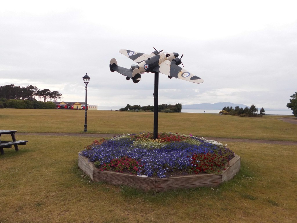
A model of a Lockheed Hudson built by apprentices at Gen2 College in Workington commemorates the pilots of Hudsons that flew from Silloth Airfield in the Second World War as part of the No 1 Coastal Operation Training Unit. 64 planes were lost, 17 of which crashed into the Solway Firth, which then earned the black-humoured nickname of “Hudson Bay”.
Silloth is certainly quaint, I wouldn’t go so far as saying antiquated, but their police force could probably do with some new equipment.

Across the park is a squat building, which was once the town baths according to old maps of the area. It’s now an amusement arcade, and has a little Thomas The Tank Engine train that chugs around the park.

I cross the grass onto the promenade and wander northwards to the car park where I left my car.

A brown giant sat on a bench with his dog waves cheerily at me, and I wave back. His dog ignores me.

The sculpture is called “Big Fella” by Ray Lonsdale.
This walk was completed on 4th July 2021, and is about 13.3 miles long. Here’s the map:

And here’s a real-time recorded map of my actual route, which you can pan and zoom around (just click on it if it’s moaning about WebGL, I don’t know why it’s started doing that).
Read some other coastal walkers’ write-ups for this section, just click on the image…


Wow Paul, you’re nearly in Scotland. World class hiking. 👏
Thanks Tom! Still 4 walks off Scotland…. unless I take a shortcut across the Solway Firth! It is possible at low tide with a guide. Hmmmm….
How have you found the Cumbria coast? I’ve recently backpacked around Anglesey then along the North Wales Coast, Mersey and Lancashire Coast as far as Arnside. But from there on I’m doing more of a Grand Tour of the British Isles and not sticking doggedly to the coast if it would be more enjoyable slightly inland, so I’m inclined to do a few loops inland around Cumbria. Were there any sections of the Cumbria coast which should not be missed?
It does look a very featureless coastline. I believe I went to a Sunday School Picnic in Silloth when I was about 4 but I don’t remember it!
It would definitely be more scenic inland John. The Cumbrian coast isn’t that great. Around Arnside it’s lovely, and St Bees Head is really nice, but they call it the Lake District and not the Beach District for good reason!
Splendid stuff. No sentimental blosh about the endless sand. I know the feeling. It’s similar with railway tracks converted to footpaths. I’m off tomorrow for a four day stint with Bowland Climber to finish off our straight grid line across the country. We started before Lockdown at Blackpool and will end up on the east coast on Saturday north of Hull. Our day tomorrow involves a longish stint on one of those ex-railways.
That’s quite a project you’ve got going there Conrad! I’ve been reading your exploits.
The endless sand is pretty boring, but preferable to trudging along lanes which is what a lot of the next section will be. After that I have an option to wade across the Solway Firth (with a guide) which could be a lot more interesting than following the coast to Gretna!
Our paths almost crossed Paul, I was in Allonby myself only yesterday (Monday) A shame it was dull when you were there, it was glorious yesterday. There’s more to the village than you think if you take the time to explore, especially in the history of many of the cottages and other buildings, it also has connections to Charles Dickens and Wilkie Collins. I wrote two posts on it a couple of years ago, if you’re interested have a look at this one –
https://mousehouselife.wordpress.com/2019/07/05/allonby-village-past-and-present-1/
and the following one.
A shame you got muddy wet feet, I hope you soon dried out. I like the new bike, it will come in very useful in places with little or no public transport.
Hi Eunice, as I was reading Paul’s account I was thinking of you 😉 And clearly you are home safely and back connected to the internet.
Paul – lovely account of your walk, sorry you found the muddy patches. At least you survived OK, it can be a little treacherous in places.
Well I didn’t realise it had so much! I only read about the Alms house afterwards, and then spotted a cafe as I drove through it to pick up my bike, so perhaps I should have gone through it after all!
Many people will just pass through Allonby as you did, but it’s a very interesting place when you start delving into the history of it 🙂
Bloody hell, no time to comment, just realised I’m off with Sir Hugh tomorrow, dreadful early start.
We may reach the beach in four days.
That’s quite an adventure you’re on there BC!
Love the police car! Hiking poles are good for the mud / sand testing. The bike is an excellent idea. I may need something similar down the line.
Yeah, I’m in two minds about hiking poles. I really don’t like having to carry things in my hands, so have never bothered with them before, but they would have saved me from wet/muddy/slurried feet several times so far!
I bet you were glad to get to Silloth. I think the vibrant blue flowers you saw were Vipers Bugloss. 🙂
Yes, Silloth is really nice, and much more interesting than 13 miles of sand! 😄
Thanks for the flower spot!
Hi Paul, sorry I seem to have neglected reading your excellent blog, but are pleased to see you making good progress up the West Coast. Many years ago I had an electric bike. I built it from a donor bike and bought the front wheel motor and controller/ battery’ s online. Bascially , it was crap. The batteries were lead-acid and weighed a ton! Lithium were still expensive back then . I did have a 900w motor (by law the max is 250w), but it was a wasteof money.
walking along sand for that distance can get really boring, like yourself I like to shift between the beach and the shore to get different views. Its been 5 years since I passed through Silloth, I remember it well because it was around Chrsitmas time and popped into a buthers to get some proper Cumberland sausage. Cheers for now . Alan
I remember being delighted with Silloth. You are right it is the most delightful town. Getting out was a hassle. A taxi to Wigton. If you are bored by endless beaches just wait till you get to Lincolnshire. I’ve just walked 17 miles of endless coastal banks and you still don’t get to see the fricking sea.
😄