
Today the sun is shining, and that makes a big difference. I still pack the umbrella in my rucksack – this is Scotland after all. Since my hotel is in Dumfries, I don’t need the car today… a ten minute walk to the bus stop, and a short bus journey, and I’m in Bankend again. The last time I was here I wasn’t very happy. It was raining and I’d just finished a walk that was nearly all along roads, with no view of the sea. Today is very different.
My legs feel quite tired from the previous two days of walking, and I’ve just realised that my planned route of 13 miles had the wrong start point, and this is going to be 14½ miles, I’m a little apprehensive, but the sun is shining, what the hell!
The bus drops me in the village itself, but the previous section ended down by the river, so first I have to head down there to ensure the sections link up. At the stone bridge over Lochar Water, Lochar Tower peeps through the trees. This tower house, built in 1565, was owned by the Maxwell family, but the Maxwells back then were no more popular than they are today, and just five years later it was burnt down by someone called Lord Scrope – “Scrope the scrote” as he’d be nicknamed today. Today it’s a ruin. Just like the Maxwells.

The B725 southwards out of Bankend towards the coast is no nicer than the section of it that I trod yesterday, but my mood is much brighter, just like the weather, and that makes all the difference. I pass a house with a beautiful garden and a strange water feature. The concept of using an old coffin is unique, particularly if the body is still in it, but I couldn’t tell from my angle.


I turn left down a lane leading to Caerlaverock Wetland Centre. A flock of hedge sparrows flit about on the road ahead of me, pecking at the ground, flying back into the hedge when I approach.

To my right lies the looming mass of Criffel. This is the first time I’ve seen the top of it – it’s been shrouded in cloud every day I’ve been here until now. I have no desire whatsoever to climb up it as the top doesn’t look any more interesting than the bottom. It’s not quite a mountain yet, only 570 metres high so still has 30 metres to grow.

The lane ends at a junction. Left takes me to the Caerlaverock Wetland Centre, and right to Caerlaverock National Nature Reserve. I’m not particularly interested in visiting either of them, but the left turn keeps me closest to the coast, so under my guiding principle No 2, that’s the way I go.

My planned route continues straight on, through the wetlands centre, then turns right to the coast. The only way in though is through the shop, and inside a sign tells me it’s £8.50 entry fee (and £9.00 if you do gift aid – how does that work, they get more if you do gift aid so why are you charged more?). There’s no way I’m paying that much just to be nearer the coast for a few hundred yards, so I head down a wet track just before the wetlands centre.

This ends at a gate into a field full of bushes and brambles. It would be quite a battle getting through that, but then I notice one of those yellow circular signs indicating a footpath, pointing right, where there’s a narrow grassy path between two hedges. I’m not sure many people go down this way – the grass is long and still very wet from the rain yesterday. My socks start getting soggy through my supposedly waterproof walking shoes. I never got round to spraying them because they were so muddy, and I never got round to washing them… you know how it goes.

The path opens out a bit later on, with shorter grass – clearly more heavily used at this end. Eventually it turns left and heads into a marsh with well-maintained boardwalks. This is much better.

Past a picnic area and a bird hide, the boardwalks end and the path reverts to grass, but it’s short and easy going. Although just like yesterday I’m still not close to the sea, it’s so much better when the weather is nice. In fact it’s getting really hot, and I have to keep removing my hat to let my head cool down!

After a mile or so the path leads into woods, and it’s a relief to be out of the sun for a while.

There are occasional benches, with dedications to people who have passed away. This one from work colleagues.

I wonder what I might get from my work colleagues if I died. Perhaps some words scribbled on one of the Biffa Bins with a Sharpie, “He was OK” or something… hmmm, that’d be nice.
The path skirts about half a mile away from Caerlaverock Castle, which apparently is quite impressive, but I can’t see it from the path for all the trees. You have to pay to get inside, but it’s closed at the moment anyway for “masonry inspections”. I don’t feel inclined to add a mile there and back to my walk.
The lovely path eventually ends at the ubiquitous B725, and I must follow it for around three miles. There’s no pavement, but it’s not very busy.

Far away to my right a copse of trees is perched up on the crown of a hill. The hill is called Ward Law, where once was a Roman camp. It’s up a hill, so I have no appetite to go up there either.

I’d forgotten about my wet socks, but when I reach a park bench overlooking the estuary, I take the opportunity to let my feet dry out in the sunshine and put on a dry pair. The view is very nice.

Out in the shallows an egret and a couple of Godwits are looking for their lunch.


In the height of summer the days are long in the north, but still this surprised me…

The road eventually reaches Glencaple, where ships once set sail for America and the West Indies. There was also a shipyard which built schooners. There’s no industry left now, only a big cafe and shop, and plenty of motorhomes. I take the opportunity to stop on a bench and have some lunch.

A path keeps closer to the river and allows me to finally get off the road. Although boggy in places, little bridges span larger streams, and haaf nets lie stacked up next to the river at various points.

The path crosses a larger stream with a more substantial bridge, and then I have a choice. Go back onto the road, or tackle the “Bridge Of Menace”…

This is the route that several previous coastal walkers have taken, but the bridge is gradually deteriorating. It was lopsided when Ruth came through here in 2017, but since then they’ve cut off all the railings and floorboards, leaving only the wooden frame, I guess to discourage people from using it. But that only makes the challenge more tempting, and besides, I’ve had enough of roads.

I’m slightly nervous attempting this, and the growing audience willing for me to get a dunking in the mud doesn’t help…


I warily inch my way across, and jump down onto the bank at the far end. The cows are disappointed.
The path continues northwards, sometimes indistinct but mostly easy to navigate, past cowfields and cornfields. Near Kingholm Quay, transmission lines cross the River Nith via two tall pylons. There’s no sound coming from these, no buzzing, no crackling, as no one can afford the electricity they carry anymore.

Kingholm Quay was built in 1747 as part of the Port of Dumfries, and was a fairly major port for ships trading with North America, and especially passenger traffic from Dumfries to Canada. Today it serves as a centre for teenage snoggers, and a specially adapted bus shelter has been provided for the regular stream of customers.


Next to the road is The Swan pub, with a lovely shady beer garden. I’m hot and tired and so in I go. Inside the barmaid tell me it’s shut, but I manage to pull such a heartbroken face she takes pity on me and pours me a pint of cold lager. Ah, this is nice.

From Kingholm Quay the path is paved all the way into Dumfries.

The lowest bridge over the River Nith is called the Kirkpatrick Macmillan Bridge. Mr Macmillan was a blacksmith, and supposedly the inventor of the pedal bicycle – not of the bicycle itself though, and a plaque proudly records his achievements. It turns out that he probably didn’t invent the pedal-powered version either, but what the hell, why not build a footbridge in his honour anyway? The people of Dumfries couldn’t think of a good reason, and so here it is, and it’s very nice too.

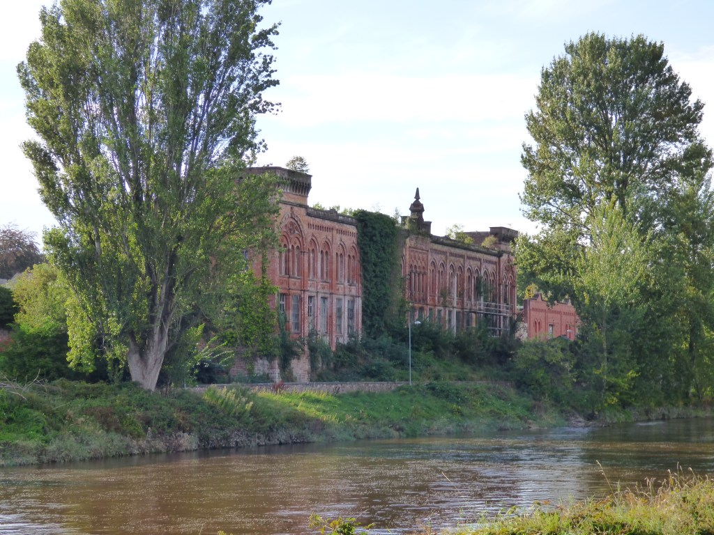
The path enters the pleasant Dock Park, set next to the river. On the opposite bank is the old Rosefield Mill, built in 1886 for the manufacture of tweed. It’s a lovely grand building, but now falling into ruin, what a shame. If that was in Manchester it would be full of apartments, which would upset some people, but at least it wouldn’t be falling down.
A couple more bridges go by… well, actually I go by, the bridges thankfully stay where they are (unlike the bridges over the River Annan)… St Michael’s road bridge and the Dumfries Suspension bridge for pedestrians.


Dumfries is well blessed for bridges over the River Nith, having ten in all. The next one I get to is the Devorgilla Bridge in the town centre. A wooden bridge originally stood here, but this stone one was built around 1432, and named after Dervorguilla de Balliol, mother of King John Balliol of Scotland. After a flood destroyed it in 1619, only the arch at the far western end remained, and the rest of the bridge that stands here today was built using the preserved fragments. Originally it had nine arches but the enterprising people of Dumfries reclaimed the land underneath three of them. After several more road bridges were built it was closed to cars and is now a pedestrian bridge only, the twelve steps at the eastern end being particularly difficult for cars to negotiate.

I stand for a while and watch the gulls sitting in the water just below the bridge, where there is a weir. The water flows fast and as the gulls are swept over the weir they fly a few yards back upstream to sit in the water again. I’m pretty sure they must enjoy it, as they are intelligent animals from what I’ve encountered.
My hotel is just a couple of minutes walk from here. Although this had been the longest of the last three walks, it has been the easiest because my mood has been so much better. The sun makes most things easier!
This walk was completed on 4th September 2022 and was about 14.4 miles long.
Here’s a real-time recorded map of my actual route, which you can pan and zoom around:
Well done for crossing the bridge of doom. I thought I must have taken the wrong path and headed for the road! You missed a cracking castle though, even if you can only walk round the moat.
Thanks Tony – that bridge was quite exciting – you should have given it a try, the path by the river up to Kingholm Quay was a lot nicer than that road. It wasn’t too bad to cross as long as you’re careful, at least it’s got no worse since you did it earlier this year!
I did think about the castle, but I was a bit worried about the distance since I hadn’t been out for months, and as it said it was closed anyway I really couldn’t be bothered. I saw your pictures of it though – very nice!
Good to see you out again. I wonder if you will catch up with Ruth before she finishes?
Not a chance Conrad! I don’t get out often enough these days.
Another lovely write up and some nice weather too. I wonder if that nature reserve is new. I don’t remember (or see it on the map) though I did take the path that got me a view of the castle, but also didn’t go in. I think that wobbly bridge was much as it was when Ruth saw it, certainly it had planks when I crossed it. I wish they would repair it rather than send someone out to take the planks off. What does that achieve?
That road closed sign amused me. The road is closed for 1 day from . Hmm. So is it closed for a day or a week?
I quite liked Dumfries, some nice architecture. Glad to see you making progress.
Have you picked up got Tony’s skill of being able to turn up at any pub/restaurant and get served no matter what? 🙂
Hmm I seems WordPress “ate” some of my comment. Any way the road closed sign saying the road was closed for 1 day and then giving the dates that work out at a week was what I was going on about.
Thanks Jon. The bridge was just as tilted as when Ruth was there, but with the handrails and planks removed to make it even more exciting.
The roadsign does say “weather permitting”, so perhaps they were only expecting 1 day in 7 when the weather would be good enough to do the works? That seems rather too optimistic for Scotland to me though!
I’m not as skilled as Tony yet Jon – he would have got the pint for free 😁
Hi Paul – I have only just discovered your blog. I have been following Ruth Livingstone’s for years. I walked the coast slowly too between 2009 and 2019 completing it in August of that year. I had no blog but wrote books on it under the generic title ‘Recollections Of A Coastal Walker’. If you want any help on your walk (although my books are not guidebooks) my books are only about £1.50 each on Kindle and might be of use. I look forward to following your endeavours from here on. I am now doing the inhabited islands but only half heartedly as I am spending most time on other interests such as photography, although I have published one book under the same generic title on the south east islands of England . All the best.
Hi Chris, thanks very much for that. I think I might have one of your books actually! Sorry for the delay in answering, I’ve only just looked on here again as I’m writing up the next five walks.