
I’ve had quite some time off walking around the coast, my previous walks being in September 2022. It’s good to be back, and it’s good to be dry… it’s not raining in Scotland. In fact it’s 29°C and the sun is shining.
I drove up to Dumfries this morning from Manchester, a relatively easy drive, and parked up at the end of this walk, Drumburn Viewpoint, a layby off the A710. It’s a very nice layby as laybys go, with views over the nearby fields, across the River Nith and over to Cumbria, where I can still make out the Skinburness peninsula and the radio masts at Anthorn.

I cross the road to where the bus will hopefully pick me up to take me to the start point in Dumfries. There’s no bus stop sign, so I hope the driver is in a good mood and stops for me. A lady driving down an adjoining lane stops and asks me if I’m looking for the path up Criffel. “God no!“, I respond, and realising that sounds a bit rude expand upon it. “No, I’m walking around the coast, I try to avoid hills, especially big ones like that.”
After explaining about the bus stop she very kindly offers to drive me into Dumfries. On the way she tells me she is a hiker, and has recently walked from her house near here over the highlands to Cape Wrath, averaging 50km a day. I feel quite inadequate. I’ve never thought of myself as a real hiker, more a sort of stroller, and feel even more that way now.
She drops me near my start point, the eastern end of the Devorgilla Bridge over the River Nith, and off I go, over the bridge.

At the far end of the bridge stands Old Bridge House. Unsurprisingly, this is an old house that sits on the bridge. Or maybe a newer house that sits on the old bridge? Hmm.
It turns out to be the oldest house in Dumfries, so Old Bridge Old House wouldn’t be inappropriate. It’s a museum now, but as I’ve only just started I don’t go in, and advertised exhibits such as an “early dentists’ surgery” don’t fill me with any excitement.
This western end of the bridge brings me to the suburb of Troqueer, which used to be a separate village from Dumfries. This marks the start of the old county of Kirkcudbrightshire, quite a mouthful to read. It’s pronounced differently but no easier to say… Ker-coo-bree-sher – but as no one uses that historic county name anymore it doesn’t matter very much. The eminent Covenanter John Blackadder was ordained minister of the Troqueer parish in 1653, but was expelled from his parish in 1662 for refusing to comply with the Episcopacy and spending too much time making TV comedy shows.
A lane heads south on the Ker-thingy side of the river and shortly opens up into a grassy tree-shaded area, where several locals expose their snow-white tans to the shiny thing in the sky that visits here once or twice a year.

The old ruin of Rosefield Mill seems to be in a worse state than when I passed on the other side of the river in September. [Update 12th Jan 2024: Thankfully, it seems something is being done to rescue this building – see here]. The roof has completely gone and sunshine beams through the windows, in the wrong direction.

A large concrete cross-shaped structure sits on the river bank, I guess something to do with water works rather than a brutalist religious sculpture, but I don’t know for sure.

Just beyond is a Path Closed sign, which I ignore like I always do, passing the feeble attempt to keep people out.

This time the reason is that the path is falling into the river, but I manage not to.

A huge briar rose bush wafts its scent across my path, and the path swings right away from the river and over a footbridge, which like the path before is falling into a river. It still seems solid enough and I stay dry.


The path meanders through a wood and widens to become a road – Mavis Grove – an odd name. On the left a house boasts an impressive radio mast. This seems excessive even by the standards of the most eager radio hams, with line-of-sight microwave dishes, mobile phone arrays, and Yagi antennas (sorry, can’t help myself). I’d have a go at tuning in to Radio Mavis Grove, but I didn’t pack a radio, and I suspect it might be rather dull anyway.

Mavis Grove is quiet, short and straight, and leads to the A710 which isn’t any of those three things, and I spend the next three miles or so dodging traffic, swapping sides to keep to the outside on the bends. It’s not much fun, but the sun is out and I’m not tired yet, so I’m happy enough.
I pass a slightly creepy house, Nethertown, which reminds me of the house from the 1988 dark fantasy film Paperhouse (which is great, watch it), but now writing this blog I realise it’s not much like it at all. Still quite creepy though.


The road reaches the village of Islesteps, and I wonder how to pronounce this. Eye-zel-steps sounds best to me, but it’s probably “Isle-steps”. The river that flows through it seems a bit small to host any isles, but there are some steps down to it. The isle could be invisible I suppose, or it could be so low that it’s submerged, but then it wouldn’t be an isle at all, would it?… just a bump under the water. I give up wondering and move on.

The pavement ends before leaving Islesteps, and I resort to walking along the edge of the road. Occasionally there is a grassy embankment that makes walking nicer… this one accompanied by a nice mossy wall…

Not much to say about it, except it’s nice and I like it. A pretty yellow weed grows next to the road, Dotted Loosestrife according to my PlantSnap app. It goes in my wild flowers collection.

A little further on is a hexagonal house, presumably a gatehouse for Mabie House, which lies off to the right somewhere. Mabie House is now a hotel, and isn’t very interesting. The gatehouse is more so, and sports an array of Scottish independence banners.

Finally, I can leave the A710 by following a lane to Kirkconnell Flow Nature Reserve. Right at the start of the lane, two gateposts marked “Kirconnell House” either side of the lane have toppled over. Ominous.


The lane is nice, but long and eventually a bit boring. There appeared to be a nicer route through the nature reserve, but on my maps I couldn’t see it joining back up with the lane. Reading other people’s blogs it does, and I clearly should have paid more attention! However, if I’d done that I wouldn’t have met these fine inquisitive young fellows…

A field shimmers pink next to me, and I peek closer to see what is growing there. It’s just grass flower heads. The photo doesn’t express how pink it seems in real life.


At the end of the lane two miles further on is Kirconnell House, the first house in Scotland to be built from bricks, in 1760. This was the location of the house of the Maxwell family from around 1430 right up to 2001, when Francis Maxwell sold it to pay for his losses with Lloyds Insurance, and divorce payments. I feel as sorry for him, gambling his inherited wealth, as he would have been for me had I lost my entire £35.26 savings down at Gala Bingo. Apparently he retained around 80 acres of land and the barony with the title Kirkconnell. I’d retain my back garden and all the derogatory names my mates call me if I lost my savings too, so fair enough.
At the house, I dogleg left then right, and follow a more rugged lane up to a pumping station at Airds Point. Apparently effluent from the Dupont Teijin Films factory at Cargenbridge near Dumfries is pumped here and discharged at high tide, a mixture of surface water, trade effluent and treated sewage. Lovely. Thankfully it’s low tide at the moment.

A path skirts round the seaward side of the site, allowing me views across the mouth of the River Nith and the Solway Firth, and then enters Knocktor Wood.


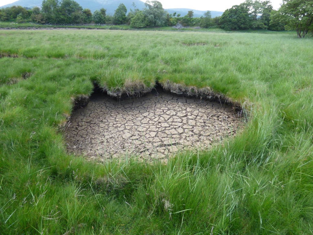
After a half mile or so, the path leaves the wood for a while, drifting over the machair, where many water holes dotted around the landscape have dried up with the recent hot spell.
Apparently there are two rocky coastal features here called Lot’s Wife and Adam’s Chair, but I’m guessing Adam must have run off with Lot’s wife because I can’t see anything but mud here.
The path peters out a bit, and I follow what I think is the path back into the woods. Then it peters out even more and I’m surrounded by waist high bracken with no sign of any path.

I take a look at Komoot which shows where the path actually is, and use a compass to see which way to go. After a few minutes wading through the bracken and hopping over fallen trees I get back on the path, which soon ends at a gate to a field full of sheep.

The sheep scatter and leave me to skirt the Drumillan Pow river, with Criffel looming large in the background, trapping a big black cloud. I hope that’s not coming my way!

A loud clap of thunder comes from my right, and I see rain pouring down onto the hills not far away, but after a few minutes everything clears and the sky is full of sunshine again.

A rubbly track then leads down to a ford over a stream, but luckily there’s a footbridge there too. Then the path leads through a grassy field, over a style and into the grounds of the ruined Sweetheart Abbey, in the village of New Abbey.


The abbey was founded by Dervorguilla of Galloway (the same woman who got the old bridge in Dumfries built) in 1275 in memory of her husband John de Balliol. She kept his heart in the abbey, after he died (presumably after, or else very shortly before), hence the name of the abbey. His heart is no longer there, or at least I couldn’t find it.

Unfortunately, after New Abbey, the route rejoins the A710, and it’s a 3 mile slog to the Drumburn viewpoint and my car. I’ll spare you all but one of the photos of three miles of Scottish A-road…

There, that one is the most interesting of them.
This walk was completed on 10th June 2023 and was 13.5 miles long.
Here’s a real-time recorded map of my actual route, which you can pan and zoom around:
Good to have you back for some chuckles to offset against most items of current undigestible news,.You may even complete this walk before the planet is totally trashed?
Thanks Conrad, but I fear the planet-trashing event will come when I’m around Paisley, although it could be tricky to notice the difference there!
Welcome back Paul. I thought you had packed away your hiking boots for good. You made the right call to avoid the Kirkconnell Flow Nature Reserve. All I found were bogs!
I just ended up (accidently) walking round in a complete circle through that nature reserve and ended up right back where I started. Rather than try again to see if I could spot a turning I missed, I gave up and walked onwards along the road!
It was so dry that week it probably would have been OK, but if you wanted to do the best route you’d have to do a second lap after learning from all the mistakes from the first one! Not sure I fancy that!
Welcome back! You were lucky with that rain scooting past you like that!
You were also a lot better at avoiding Criffel than I was. Like you, I had no intention to climb it, but a wrong turn on a road-avoiding footpath after New Abbey sent me up it anyway.
By the time I’d got to New Abbey I was knackered, having not walked since September, so I was happy to trudge along the road. Any path that looked remotely uphill I was definitely not going to try out!
Good to see you back on your walks Paul, I thought maybe work/time constraints had made you decide to give up as you got farther away from home. I’m glad you managed not to fall in the river and the rain missed you as well. It’s raining here as I type this, if it’s fine tomorrow I’ll be round your neck of the woods on another street art hunt.
A good walk and good to see you back on the coast, I was hoping you had not given up.
Hi Paul. A very informative description of your walk,grade AA+ . Hope you do some more walking. Take care. Robert.
What, no wading through rivers? Hope you are up there for a few days walking for us to follow.
I did have my eye on the lower reaches of the River Nith on the last walk, which would have rendered this one unnecessary, but it looked very silty, and I probably would have ended up neck deep in silt!
Yes, I was there for five days, so four more to come (well, 3½ anyway).
All good stuff.
‘A’ road walking sucks. How are you managing these longer walk sequences
Do you centre yourself at one B&B or stay in a string and pick up your car at the end of the day
I normally find a decent enough (but cheap) hotel and stay there for the duration. The drives back and forth are generally only 30 minutes, so it saves all the checking in and out and stuff. This time it was The Star in Twynholm, a friendly pub with 3 rooms which I’d recommend, and only £40 a night.