
I’m all set to leave the hotel with twenty minutes to spare, when the friendly landlady engages me in conversation. She’s interested in what I’m doing and what I think of Dumfries and Galloway. It’s nice to talk about my adventure, but it does mean that I’m leaving ten minutes later than planned.
I drive to the end of this walk, but heading into Dalbeattie through a slow set of roadworks, I realise I’ve set the destination wrong in Google Maps. Doh! A U-turn, and back through the slow roadworks again, and I head down the A711 towards Palnackie, only to see the bus I was intending to catch passing by me in the opposite direction. There’s only one bus every two hours, so it looks like I’m going to be on my electric bike today. Luckily this is one of those walks where the coastal route is much longer than the road route, so it’s only a six-mile cycle ride, short enough that the battery will take me all the way and I don’t need to pedal… my sort of bike ride!
I lock the bike up at that same picturesque but shockingly expensive car park in Dalbeattie Town Wood, relieved at least that they don’t charge for bikes.

Dalbeattie Town Wood is right on the southern border of the town itself. Turning right out of the car park, I walk past the welcome sign, and up High Street towards the town centre.

Strangely for a High Street, it is mostly lined with houses. Small Scottish houses have a style all of themselves. It’s a bungalow-with-a-dormer pattern that has lasted over the centuries – you get very old cottages like it, and modern ones almost identical. I can’t say I particularly like it, but the Scots clearly do.


Not all Scottish houses look like that of course, but whatever the design, however old, however new, they are depressingly fond of grey. When your weather is mostly grey, why would you choose to match it with your houses? I think about those lovely houses in Tobermory, painted all different pastel colours… maybe the people responsible for those were hounded off the mainland for their heresy? Dalbeattie remains stubbornly grey.


As I come into the town centre, some heretic has strung coloured flags from each side of the street… won’t be long until they’re shipped off to Tobermory.

I turn left, heading towards the Urr Water, and into a park with attractive footbridges on each side crossing the Barr Burn that almost encircles the park. I’m followed by a dog who throws himself into the burn, prancing and splashing around in the water, showing off to whoever will watch him… just me.


On Craignair Road (the A711) heading out of town westwards, I overtake the traffic queuing up to get through those roadworks that made me miss the bus. In the distance, looming over the flood plain of the Urr, is a scar of red rock, exposed by the workings of Craignair Quarry.


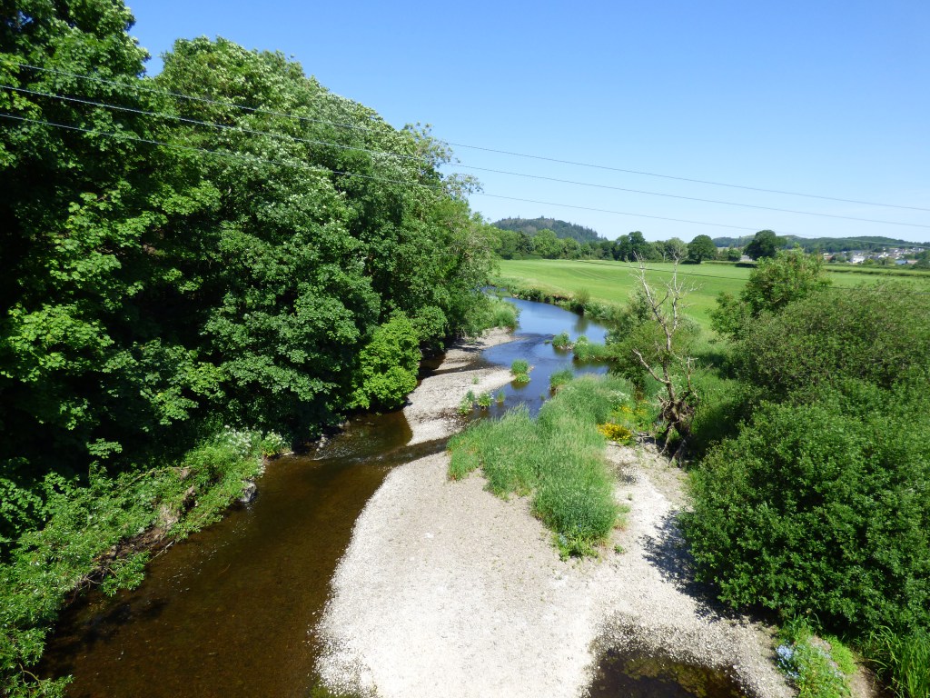
At the bridge over Urr Water I look down at the river. I’ve walked ten miles up the estuary, and I’ll walk another ten down this side to get over that. I wouldn’t even get my knees wet wading across it here.

At the end of the bridge the A711 swings to the left, as do I. Well I don’t swing left, that would be odd, I just turn left like you do when you’re walking. I’m about to step over a fibre line that BT workers are hauling up onto telegraph poles, when one kindly raises the cable to allow me to pass underneath, preventing a potentially embarrassing accident.
To keep closest to the coast, or in this case the river, would mean continuing along the A711, but that isn’t very interesting. It’s not a very busy road, but there’s no pavement. My route on Komoot shows a right turn up someone’s drive and into some woods, but that someone has other ideas, as they have erected a sign making it quite clear that the footpath doesn’t go up there. I check the OS map, but it doesn’t show any paths, public or not, so I stay on the road a bit longer, hoping I’m allowed up the next right turn.

I arrive at the turn off, and sure enough there is a core path sign pointing up to Kirkennan Woodlands. But turning the corner, I encounter a different problem.

The cows have been penned in between two gates about 10 metres apart. A quad bike sits passengerless beyond the second gate. In the absence of a farmer, I ask the cows if they would kindly let me through, without squashing me to death between them and trampling over my lifeless body. They look back at me condescendingly, without even bothering to respond. The answer’s self-evident, and I’m going to have to find another way round.
I climb over the gate to my left and wander down the edge of the field. Once past the second gate, I squeeze through a gap in the fence and back onto the track. The cows stare at me uncaringly. “Bloody rude” I mutter under my breath. One of them frowns threateningly. I move quickly on.
The track through the woods passes through glades of broad-leaved trees, and open areas dotted with broom, unfortunately past its flowering period, then arrives in the front garden of a white cottage. Feeling a little self-conscious, I quickly cross past their front door and through the gate the other side where the core path continues.


A sign next to the track says I’m in “Munches Estate“, which reminds me how hungry I am. In a little clearing a tree has been blown down, so I sit on the fallen trunk and munch.


The track finally rejoins the A711, just as it snakes through a series of bends. Shortly before Palnackie, the Urr Water comes close to the road, sunlight glittering off its muddy banks.

Palnackie greets visitors with a boat full of flowers, very nice, and an old filling station where the only thing being filled is a skip out front, not quite so nice, although quaint in its own special way.


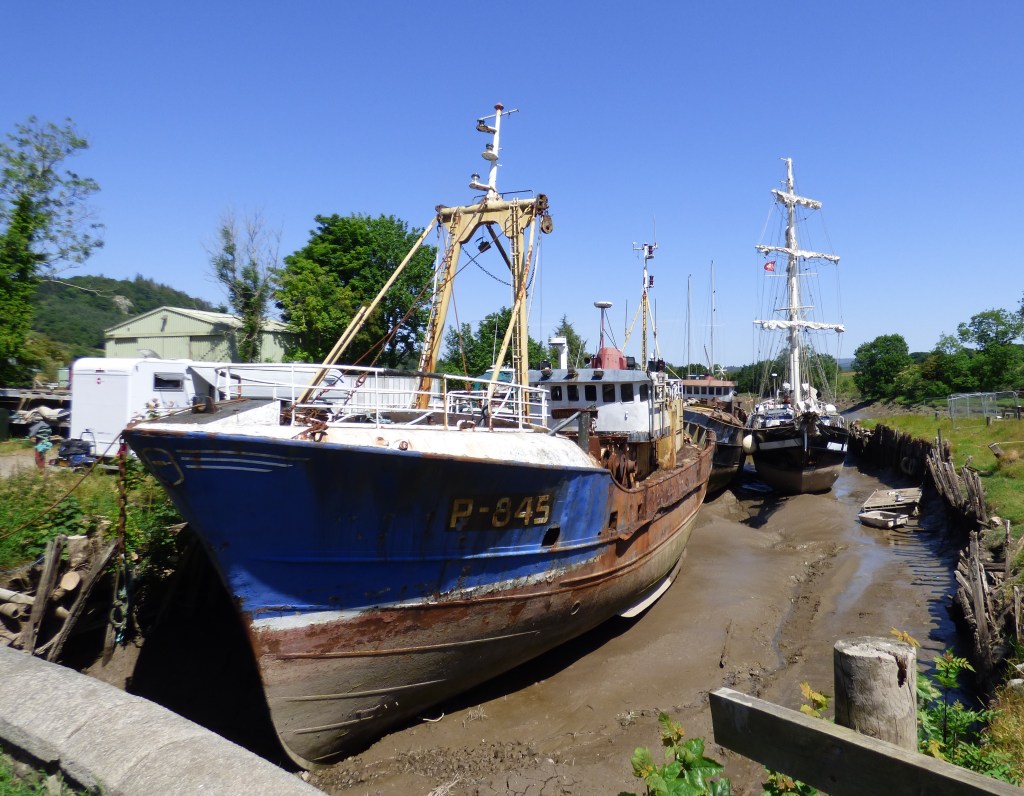
I take a short detour down to Palnackie Docks, which is still in use, to take a look at a sailing boat moored up there (La Malouine), alongside a beam trawler (Verwachtung). [La Malouine sailed out of Palnackie on 10th July – a video of it can be found here].
Although it only has a population of 250, Palnackie is still large enough to hold the prestigious World Flounder Tramping Championships, where hundreds of thousands of spectators flock to southwest Scotland to see several hundred highly toned athletes standing on fish. I’m devastated that it is held in early August and I can’t be there for it. How did I manage to mess up my visit times so badly?
On the way back from the harbour, a hosepipe has sprung a leak, squirting water into the air, where a hot and bothered crow takes a cooling shower and drink.

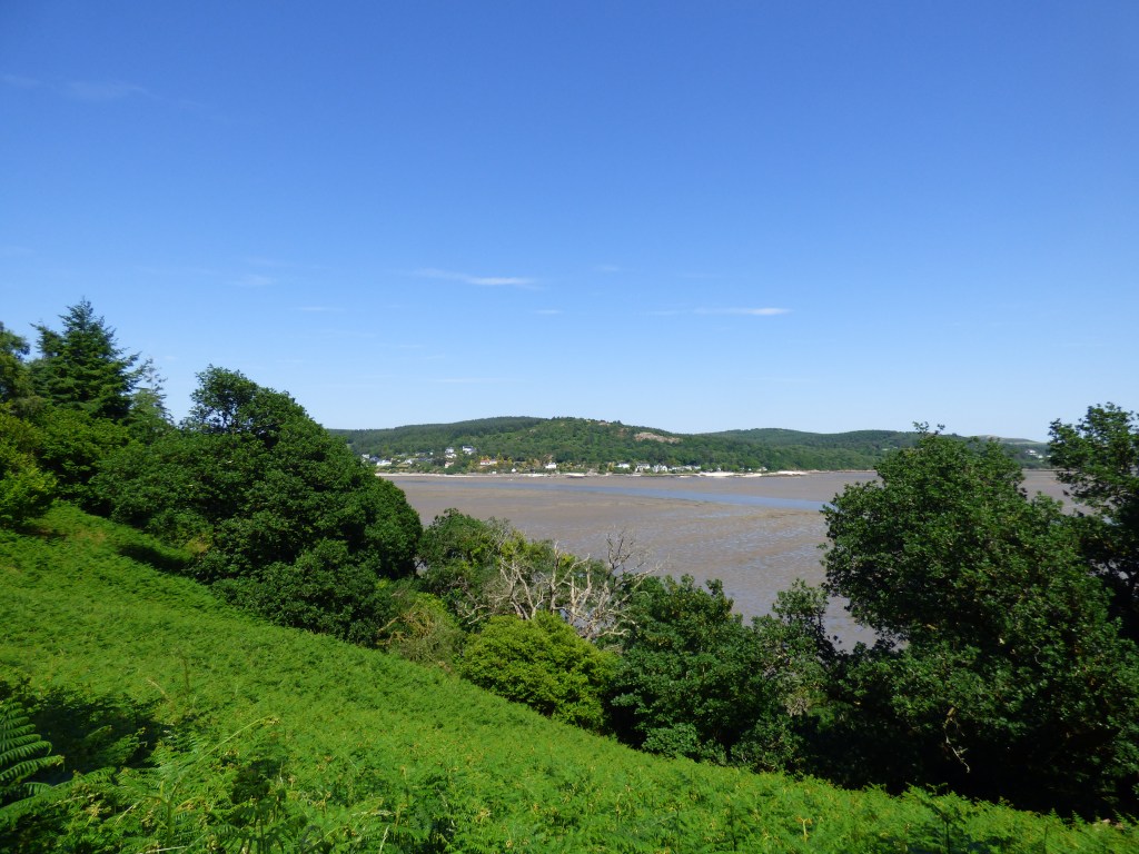
The lane out of Palnackie climbs up a hill to the Palnackie Millenium Viewpoint, a small public garden with views out over Urr Water and Dalbeattie forest. There’s a nice sculpted bench and table, where I spread out the remains of my snacks and drinks, tuck in, and enjoy the views. Very nice.


A loud rumble disturbs my lunch and I look up, to see a flight of three military transport aircraft passing overhead. [Later I find out they were on their way to a flypast to bid farewell to the Hercules aircraft]. The planes fly over the horizon… bye bye Hercules, although I’m not sure anyone is really that teary-eyed about it, it’s not the most charismatic of aeroplanes. Like saying goodbye to a Vauxhall Cargo van.

It’s a very nice place here, and I’m not in a hurry to move on, but I know I should. Eventually I drag myself up and continue walking. A short distance up the lane is a Scottish Forestry signpost to Tornat Plantation, and I take a left turn onto the path through the forest.


It’s a pleasant walk (apart from those bloody flies buzzing round my head whenever I’m in the shade), which occasionally comes close to the river edge. Across the estuary is Kippford, still baking in the sun as it was when I was there yesterday.

The path emerges onto an open plain, with Glen Isle in front of me. This isn’t an island, but a raised piece of land poking out into the sea. It’s a strange place, where sheds, chalets, and wooden lodges are dotted amongst the trees which cover the “isle”, some available for holiday rental. I wonder how it evolved, did it just grow, illegally, like those weird huts at Lowsy Point in Cumbria, or was it all planned and developed? I can’t find any information about the place.

I could walk to the end of it, as Ruth did when she came round here. She came across a man in his underpants, and not wishing to repeat the encounter, and my rules not requiring me to visit a penisula with only one path in and out, I decide to skip it.
I have decided to walk to the end of the Almorness peninsula though. My intended route is blocked by an electric fence and a field with a pony in it, but there’s another path just north of the field, which meanders through tall reeds, just above the edge of the salt marsh, then rises to join a path which heads out to Almorness Point.


The path meanders through the trees, up and down, occasionally dipping under tree branches, past a workshed and a cottage, with occasional views of Rough Firth and the Urr Water.


After a mile or so, the path eventually arrives at a gate to a field next to a big pink house. And a problem…


I can’t work out whether he looks bored or angry. He doesn’t look particularly happy. I give him a long hard stare (that’ll show him who’s boss), climb over the gate and follow the track through the field. My technique of dealing with cows and bulls is not to give them any eye contact, just occasional sideways glances to see where they are, don’t come too close, and act as if I’m ignoring them. Essentially just don’t look like any sort of threat. The bull stares at me, but doesn’t move, and I get to the gate on the other side of the field with no problems. He was obviously just bored.
From here, I can see the sea on both sides of Almorness peninsula.

I turn left at the junction to follow the track southwards. The track passes mostly through woodland. In a clearing, a rack holds some simple handmade oars, which is a little strange as it’s in the middle of the peninsula here, quite a way from the sea. Maybe they’re just a decoration… if so they don’t work. Not sure they’d work very well as oars either.

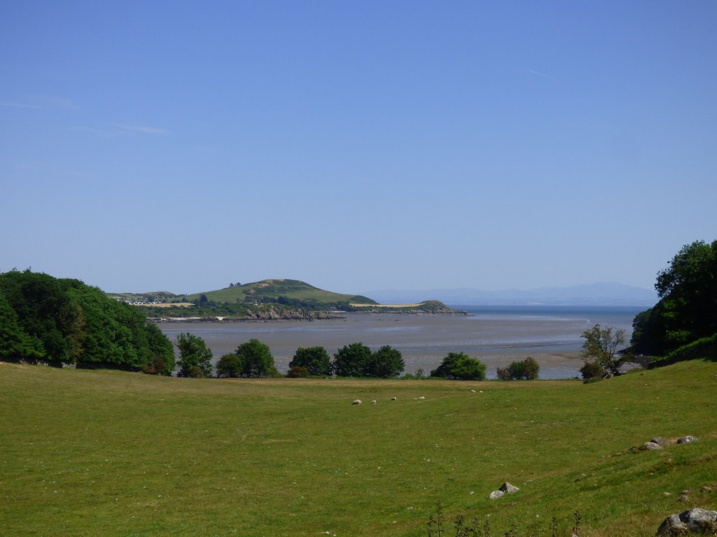
In a couple of miles I arrive at a beach in Horse Isles Bay. I’m disappointed there are no horses to be seen anywhere, but the beach is quite nice. Or it would be at high tide – it’s a bit muddy underfoot beyond the sand at the top.

The path traverses a short-cropped grass area at the top of the beach, then continues through reed-beds, through a thicket of small trees, past flowering brush bushes, then opens onto a beautiful beach, marked as White Port on the OS map.


There’s no one else on the beach. I spend a good half hour here, cooling off in the rock pools, and sitting staring out to sea. No one else arrives while I’m here. Understandable as it’s a two-mile walk from the nearest road to get here.
From the beach, there’s a good view of the lighthouse on Hestan Island. It’s not a traditional lighthouse, but still more attractive than the 18th-century Southerness lighthouse. I can’t visit it (it’s on the island and the tide is coming in) but it can still go into my lighthouse collection.

Fifteen miles across the Solway, through the turbines of Robin Rigg wind farm, Maryport in Cumbria lies shimmering in the summer haze. It was about two years ago I was walking through there.

I return the way I came, at least for the next mile or so, and arrive back at the big pink house – Almorness House according to the OS map.

Turning left, rather than taking on the bull again, the route passes down a nice lane, with a low stone wall, over which Orchardton Bay glistens in the sunlight.

At least a mile further along the lane I pass out through the gates of the Almorness House estate – the grounds must be huge.

Komoot tells me I need to turn left. There’s just a gate here into a field, but I can see another gate at the far end, so take the turn. After the far gate, a track leads up to the top of a small hill. There’s a style into the next field.


However, the field is full of cows with calves, so I keep to the very edge, amongst the big old trees and tall grass. The dry stone wall is scaleable if the cows get aggressive, but they keep their distance and just stare at me.

At the other end of the field another style leads immediately onto a footbridge crossing over a drainage ditch. I guess no one has passed this way in quite some time, as the bridge is completely overgrown with trees and brambles, and I battle my way through.

The field this side of the bridge would probably be very difficult for 360 days of the year in Scotland, as it is full of reeds and boggy type plants, but the weather for the last few days means I can walk across with no risk of wet feet. Across the other side of the dried up marsh, a track leads uphill where a flock of sheep protest loudly at my presence. Rather than stand aside or scatter and let me pass, they do as sheep always do, and follow the track ahead of me, continuing to complain that I’m following them. Occasionally one or two will go sideways and let me pass, but it takes ten minutes or so until the others cotton on. Sheep really are very stupid.


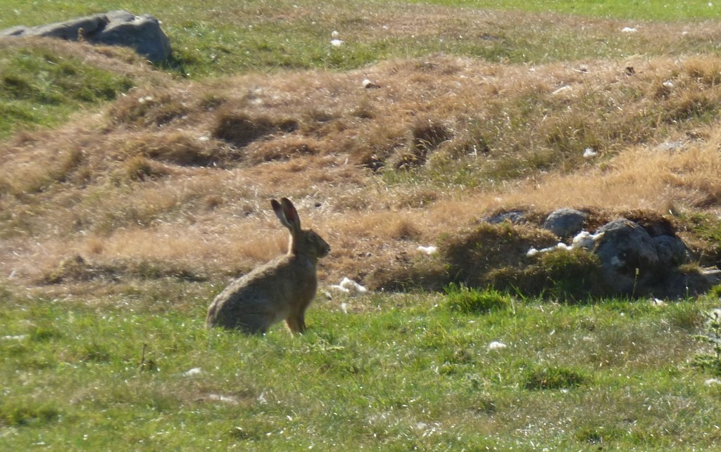
The track climbs and climbs, until at the top of the hill a pavement of stone makes a perfect seat for one last rest. A couple of hares race around playing in the sun. This is only the second time I’ve ever seen a hare.


Just beyond the limestone pavement is the gate out of the field, and a stony track which double backs on itself before joining the A711. I take a left and head south.
Over on my left is a huge house, Orchardton Castle.

The house was built in the 1880s in the Scottish Baronial style, for William Douglas Robinson-Douglas… so loved by his parents they named him twice. He was rumoured to be a smuggler, and the property has its own private beach, which I guess would come in useful. In the second world war it was used as a hospital and then converted into a hotel after the war, and then became a school.
In 2003 it was bought by Susan DeVere, who renovated it, but then decided it was just too much to deal with. Eventually, after struggling to sell it, she organised a raffle, with the castle as the main prize. Tickets were priced at £5, but when not enough people bought tickets, she gave a cash prize instead of £65,000, somewhat less than the value of the castle, which didn’t go down well with the Advertising Standards Authority. A strange story.
A few hundred yards further down the road, I reach the layby where my car is parked, and that is the end of this five-day visit to Dumfries and Galloway. The day after tomorrow I’m off to Egypt for a relaxing holiday. I was expecting a thermal shock going from Scotland to Egypt, but it’s been 29°C here, and it’s 34°C in Egypt, so I’ll hardly notice the difference. Hmmm, perhaps floating in a pool with a G&T might feel different than walking down the A710….
This walk was completed on 14th June 2023 and was 13.8 miles long.
Here’s an annotated map of my walk today:

And here’s the real-time recorded map of my actual route, which you can pan and zoom around:
White Port beach is stunning. You might mistake it for a tropical beach, until you step into the arctic water! I climbed over the electric fence although it could have been very painful! 😂
It is indeed. It was low tide when I was there so didn’t have the chance to freeze my ******** off… although an electric fence might have done more damage!
I’ve just had a look at Komoot’s website. It looks interesting but I notice, and am glad, that you are also using OS mapping which gives much more detail of the surroundings. What do you think of Komoot? An interesting post. Don’t underestimate the colour grey. John Major was nicknamed The Grey Man until he surprised us with his amorous adventures.
I really like Komoot Conrad. It’s maps come from the OpenStreetMap project, which is just a bunch of people who sign up to create the maps. I’m a member myself, and add paths that I have found, and delete ones that don’t exist or are private too. I use Komoot to plan my walks, and then when I’m walking it guides you, telling you to turn left or right, or tells you how far away from the planned route you are. Then afterwards it shows your actual route, with all the little detours as well. I find it very good, and it’s free which is even better! I did manage to change the posh RP man’s voice to a soft Irish female one too, which is much more pleasant, especially as I have a built-in block to doing anything a posh southerner tells me!
OS maps are more detailed, but of course not always correct! In Scotland the paths don’t all seem to appear on the OS maps either.
Jon Major did indeed turn out to be quite a colourful man behind the scenes! I still prefer colourful houses than grey ones though. Once I drove into Scotland around Hawick somewhere, and it seems instant as soon as you crossed the border, pretty brown-stoned Northumberland cottages are replaced by grey puritanical “dwelling places”!
Im envious of the sunny weather
Ha! Not had any of it since I did these walks, have we!
Another lovely write up of an area I am yet to explore (my only remaining “gap” left to walk is between Ballantrae near Stranraer in the north and Dalbeattie to the south – so most of Dumfries and Galloway).
Not all the houses in Scotland are grey. It will be a long time until you get there but I thought the villages of Fife were very pretty with some more colourful houses. I noticed similar in much of Wales, especially south Wales where pebble dashed cottages seem common – but of course there are also some very colourful places like Tenby.
I thought I’d commented on this when you wrote it but obviously not – a change of work hours with 6am starts must have addled my brain 🙂 I like the look of White Port beach, it’s just my kind of place, but that bull looks very mean and moody. Favourite pic for me is the Palnackie Millennium Viewpoint one, the scenery is lovely.
Just on our way back from visiting this area to mark the 20th anniversary of my father passing away. Lovely to read that you and others enjoy his memorial bench at Palnackie Millennium Park. His plaque is on the back of the bench.
It’s a lovely place to have a memorial bench Sarah. Hope you had a nice time there.